Studying hurricanes has been a something scientists have been trying to understand for a very long time. Now, using robotics, we can probe these dangerous hurricanes to try and better understand them with the hopes of knowing where they are going and how strong they will be to warn populated areas earlier and with more definitive data.
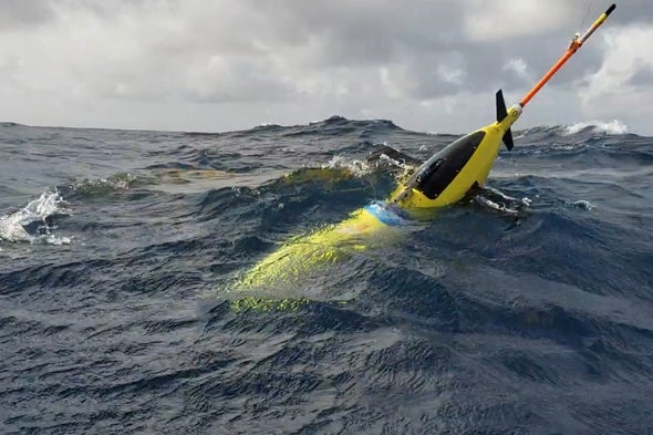
These torpedo-shaped ocean gliders can survive stormy seas and can get details of hurricanes that satellites cannot.
This year is expected to be a heavy year of hurricanes, and as hurricanes race into the warming coastal waters of the U.S., an array of sea swimming robots will be waiting for them to gain information that we have never seen before.
The torpedo-shaped machines will be positioned in areas where nothing else is location, places where no ships or humans might survive and where space satellites can’t gauge the potency of storm action. This is usually in between paths of land, wide open water.
But for the stubby-winged and narwhal-horned “Slocum ocean glider,” this is the world it was made for.
The mini-armada is one way scientists are going to better understand how these wicked storms are changing as warming oceans build their intensity and extend their inland reach.
The robots’ work appears as blips of new data on computer screens, put there by a growing navy of autonomous vehicles waiting for hurricanes in the choppy water, or cruising just beneath it.
“We have gliders that have gone through two or three hurricanes already,” explained Gustavo Goni, a lead scientist at the Atlantic Oceanographic and Meteorological Laboratory in Miami, which is run by NOAA.
“They are robust. They don’t even care. Some of them have even been in fights with sharks. We know this because we find sharks’ teeth in gliders when we recover them,” he explained in an interview.
It has taken over six years for NOAA to build up this array of floating, sensor-packed equipment. First it had to figure out the logistics of buying and experimenting with them. Then it had to train technicians how to equip and use them. And then, engineers need to be able to read the data that is passed back to the NOAA.
In 2014, the agency had two gliders ready to launch in preparation for hurricane season. As this year’s season gets underway, it will have as many as 30 waiting for missions to track and measure big storms approaching coastal areas.
And when they arrive, the robots will be mixing around in the warm ocean water that fuels these monster storms. They draw their menacing strength from surface waters, down to the depth of 74 feet, that are warmer than 79 degrees Fahrenheit. The amount of extra warmth they absorb depends on a number of variables, Goni explained.
Sometimes there is a thin layer of super-warm fresh water from rivers floating on top of coastal seawater. Sometimes the power and direction of incoming hurricanes can mix that fresh water with cooler and denser lower layers of salt water.


Leave A Comment
You must be logged in to post a comment.